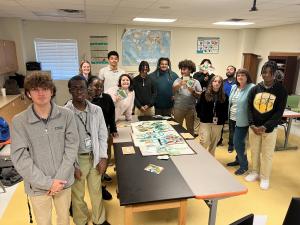
As an extension of Louisiana GIS Day, the students learned the “Watershed Game” – designed to teach students and local leaders about water quality and land use.
— Jack Dangermond, Founder & President of Esri
LAPLACE, LOUISIANA, USA, December 1, 2023 /EINPresswire.com/ — The Environmental Protection Agency (EPA) Gulf of Mexico Division Partnership Branch Manager, Jeanne Allen, joined Global Geospatial Institute’s high school GIS classes to teach “The Watershed Game – River Model.” The Watershed Game event is an extension of this year’s Louisiana GIS Day. GIS (Geographic Information System) is a computer system that analyzes and displays geographically referenced information. Throughout November, Louisiana GIS Day joined with hundreds of organizations worldwide in hosting in-person and virtual gatherings that celebrated the impact of GIS professionals and ignited the imagination of future innovators who will further advance global progress using GIS.
According to the game developers, University of Minnesota, Minnesota Sea Grant, the Watershed Game is designed to teach and prepare students and local leaders to understand community relationships between water quality and land use. The classroom version emphasizes collaborative and cooperative decision-making, persuasive argument, teamwork, leadership skills, science, and math. The goal is to reduce non-point source pollution (excess sediment or phosphorus) from various land uses to the river without going broke.
Global Geospatial Institute (GGI) is dedicated to developing students into lifelong learners who can live, compete, and successfully function in a global society. GGI does this by offering GIS Courses to high school students. Students earn an Industry-based Certification in GIS by taking the course and passing the exam.
The History of GIS Day
Over 20 years ago, Jack Dangermond, the founder and president of Esri, envisioned people collaborating and sharing how GIS affects everyone. Since the first GIS Day in 1999, the explosion of geospatial technology has expanded that idea into a global event that shows how geography and the real-world applications of GIS are making a difference in business, government, and society.
“GIS Day is a wonderful opportunity for professionals from around the world to get together to share their amazing work,” says Dangermond. “These individuals are using GIS technology to take a geographic approach in addressing unprecedented challenges, from COVID-19 to climate change. Organizations across the globe are taking part in grassroots events that help celebrate geospatial science and how it impacts the real world for good. Our users should be proud of their achievements in the field, which GIS Day is meant to showcase.”
About Global Geospatial Institute (GGI): Global Geospatial Institute is dedicated to providing parents, students, and teachers the support they need to succeed in the field of study, geospatial technology. GGI offers an engaging, rigorous, hands-on learning culture that develops innovative 21st-century citizens to compete in an ever-changing world. By introducing GIS into classrooms, GGI teaches youth the science of where and enables them to think spatially in their future courses and careers. For more information about GGI, email [email protected] or visit our website at www.gginstitute.org
About EPA Gulf of Mexico Division:
The Gulf of Mexico Division (GMD) is one of EPA’s Great Water Body Programs. Its geographic focus is on the Gulf of Mexico region’s major environmental issues and watershed. EPA’s Gulf of Mexico Division is focused on the health, productivity, and restoration of the Gulf of Mexico and the communities that rely on this national resource.
The Science Integration and Analysis Team and the Partnerships Teamwork with Gulf of Mexico stakeholders to explore methods to:
• Support assessing, developing, and implementing programs, projects, and tools that strengthen community resilience.
• Protect, enhance, and restore coastal and upland habitats within the Gulf of Mexico Watershed. • Promote and support environmental education and outreach to the Gulf of Mexico Watershed inhabitants.
• Restore and/or improve water and habitat quality to meet water quality standards in watersheds throughout the five Gulf states and the Mississippi River Basin.
For more information visit: http://www.epa.gov/gulfomexico
Fran Harvey, GISP, Managing Director of GGI
Global Geospatial Institute
+1 225-939-1091
email us here
Visit us on social media:
Facebook
LinkedIn
Instagram
Other
![]()
Originally published at https://www.einpresswire.com/article/672288003/the-epa-gulf-of-mexico-division-joined-global-geospatial-institute-in-teaching-high-school-students-about-gis-technology


